Total Solar Eclipse 2017 in Kentucky
On August 21, 2017, a total solar eclipse passed across the entire continental United States, from the Pacific Ocean to the Atlantic Ocean. While total solar eclipses occur about every 18 months, most occur over the oceans. This total solar eclipse was unique because the path of totality was visible to millions of people as it transited North America.
What We Did:
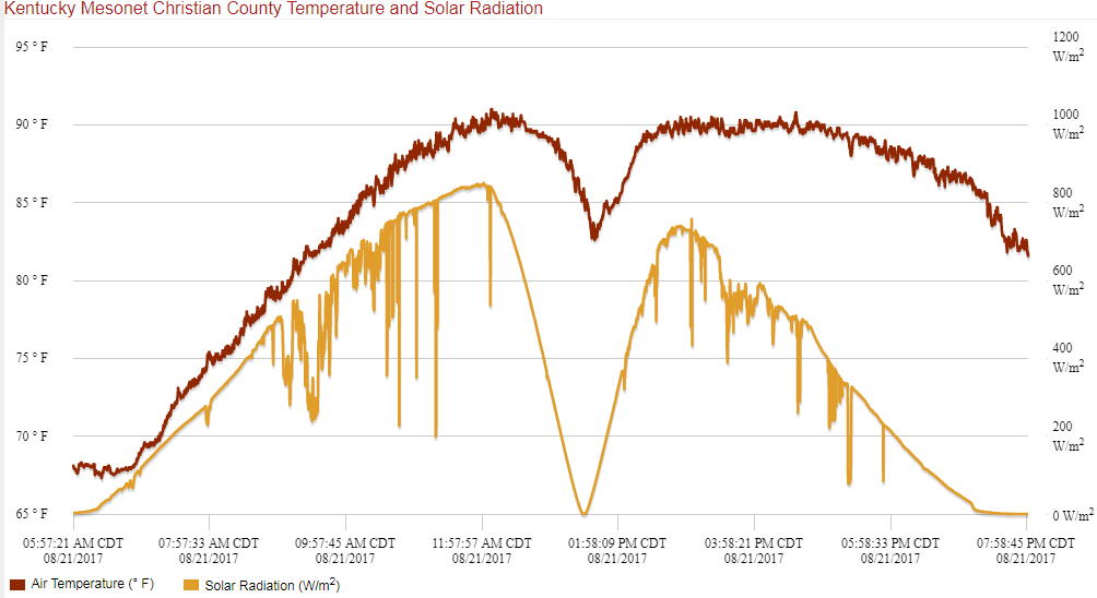
On the day of the eclipse, the Kentucky Mesonet recorded data from all 68 stations every 3 seconds for incoming solar radiation, air temperature, wind direction, and wind speed. Data was brought back every minute and air temperature and solar radiation maps were updated every minute. The Hopkinsville, KY station data was brought back every 3 seconds for a live graph (final product pictured below).
About Solar Radiation:
Solar Radiation is one of the many variables the Kentucky Mesonet measures from our network of weather stations across the state. Simply put, solar radiation data provides information on how much of the sun’s energy reaches a location on Earth during a particular time, represented as a Watt per meter squared (W/m²). The intensity of solar radiation is a function of the angle of sunlight reaching a point on the Earth. Cloud cover, air pollution, and water vapor are just a few factors that can influence the amount of solar radiation measured at the Earth’s surface.